Brad from Hanalei Taxi dropped us off at the Ke'e beach trailhead at 5:50am and we began the hike at 6am. Outside of my wife losing her Maui Jim sunglasses, the dark part of the hike was uneventful. The trail was in good condition and the lights provided plenty of vision for us. The beginning part of the trail is one of the steepest parts of the trail. You gain about 450 feet of elevation in a little under a mile so you are working up a sweat by the time you get to the first crest. The timing was perfect for us as the sun was just beginning to rise. I have posted a picture of this below.
After you make the initial crest near mile marker 1, it is generally downhill to Hanakapi'ai Beach which is near mile marker 2. We took off with 6 litres of water, comprised of two 3 litre bladders; one each in my wife's and daughter's hydration packs. We mixed the initial water with Gatorade and emergen-c thinking that it might help with the trip.
We hit the beach about an hour and fifteen minutes into the trip and felt pretty good at this point. We were on pace for 45 minute miles and that would allow us to finish the trail in our planned 8 hours. Remember, we have not been past this point on the Kalalau trail before as we have went up the valley to the falls on the previous 3 trips. Below is a picture of the sign you see when you enter the trail.
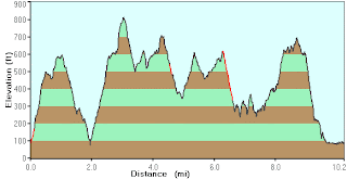
The first true test is immediately evident when you leave the beach area and begin the hike on the trail. Between mile markers 2 and 3 you gain over 750 feet of elevation. That's quite a climb in less than a mile and we were really feeling the burn as we finally got to the crest. I have pasted a picture of the GPS measurements on elevation changes below. This was to be the second hardest leg on the trail.
Your next target once you have made the initial crest near mile marker 3 is the Hanakoa Valley which you enter at about the 6 mile mark. The hike to this point is varying in terrain and is in the trees, on the hillsides and on the rocks. We did encounter a couple of small pygmy goats on our way and they were even nice enough to pose for a picture.
There is nothing really hard about miles 4 thru 6, other than you are still trying to recover from the big climb. Very beautiful views from the hillsides and dramatic scenes up the coastline to the northeast.
About 6.2 miles in, you will come to the Hanakoa Valley and a little further is the Hanakoa Campground. We stopped and had lunch here at one of the tables that are set up at the campground. There is also a composting toilet if needed. Below is a picture of the Hanakoa Valley sign. You can begin to see the tired look on the girls faces. If I would have been in the picture, it would have been even worse.
About 100 yards after you leave the Hanakoa Campground, you will come to a pretty good sized stream. It is similar in size to the one you crossed at Hanakapei'ai Beach. We made a pretty big mistake not filling up with water here as our bladders were about halfway down. Unless it's raining, this will be your best chance at getting water until mile marker 10. Again, fill up with water here if you have any room.
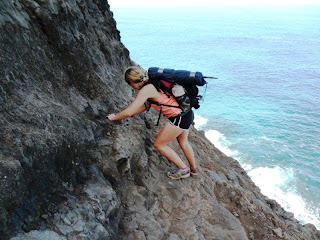
The highlight (or horror) of the trail lies one mile past the Hanakoa Campground. The infamous "Crawlers Ledge" at mile marker 7 is the reason that 60% of tourists turn around and do not complete the trail. While not really any narrower than other parts of the trail, this is a rock ledge that has fairly significant consequences should you fall off. It is several hundred feet to the rocks below and even if you survived the fall, you would probably drown in the water. There is very little that can be done to this section to make it any safer unless they decided to come in and take out part of the rock. Frankly, this is one of the primary reasons that the trail is so special. Here are a couple of pictures of the ledge as well as a video.
I was really proud of my wife and 12 year old for navigating this part of the trail. It's not too bad, but if you let it get in your head, it can be a trip killer. Kudos to both of them! They are true rock stars!
Miles 7 thru 9 are one of the best spots for pictures. The sign to the Kalalau Valley is near mile 8.5. Very scenic shots throughout the section and with the exception of on 350 climb right before mile 9, this part is fairly easy. Our challenge was that we began to run out of water at this point. We expected to see a few streams, but nothing presented itself and at mile 9, I began to worry just a little bit. At this point, we began a section that a couple of hikers refer to as "Mars". I questioned why it was called that until we got there. It is a really baron, red dirt/rock section that looks similar to pictures of the surface of Mars. It is loose and slippery, so you will want to make sure you have your trekking poles out during this part of the trail. As you can tell by the elevation chart I posted above, you can tell this is the steepest part of the the entire trail. You will want to keep your footing under you for this part.
At about mile 9.5, we were getting pretty thirsty and hot. The Mars section of the trail offers no shade and if the sun is out, you will absolutely get baked on this section. Fortunately, the best water on the trail is at mile marker 10 and we could hear it from a quarter mile away. I don't know if I have ever been so happy to see a body of water in my life. I dropped my back, jumped right into the stream; clothes and all. I was so hot that I just wanted to cool my core down before I over heated. We filled up our bladders here and then began looking for the trail out. There is no clear sign indicating where to go, but after much exploring you simply need to cross the stream at the same point as the mile marker 10 sign and you will find the trail as you go up the other side. This is a very popular spot for the campers at the Kalalau Campground as it is the purest water around there and has several swimming spots as well.
We finally crossed the river and found the trail and right at the top of the trail we saw the sign we had been waiting for. The sign for the campground stating it was only 1/2 mile away. We were all three ready at this point. It was 3:15pm and we had been on the trail for over 9 hours. Here is a picture of the sign.

We walked into the campground at 3:30pm; exactly 9 hours and 30 minutes since we began the hike. We were all in good spirits but were certainly wiped out physically.
The first thing you will see when you come in are the camping signs on the left. The camping spots are all up in the trees off the beach area and they run for about 300 yards or so. You are not supposed to camp on the beach but it looked like several people were. Ironically, the first person I ran into at the campground was someone from my hometown of Telluride, Colorado. We had both lived there for quite sometime but had never actually met in person. We had several mutual friends but hadn't met until this particular moment in time. Very surreal.
We found a great campsite about 20 yards in the trees and began to set up camp. We hopped right to it because we were all afraid that if we sat down, we wouldn't have the energy to get back up. It took us about an hour to get everything set up and ready and then we decided to go down to the beach to have a look see. There were only about 6-8 people there and it was absolutely beautiful. There is a small waterfall at the east end of the beach that most people use for water and showering. There are also composting toilets in the camp area that are a nice bonus.
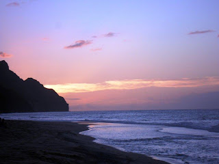
At about 5:15pm the sun began to set. It was a spectacular sunset and all three of us simply sat there enjoying the reward of our long hike. Here is a picture of the sunset that night.
After the sunset, we went back to the camp and cooked a great meal consisting of udon noodles in chicken broth. We topped it off with Hot Coco and chocolate bars. We were all so tired that we were in the tent and asleep by 8pm. I certainly suggest taking some sort of pain reliever and sleep aid for the first night. You will be glad you did.
I will update the post with days 2 and 3 in the next few days.


